
Cyclone Kirrily to form offshore tonight as Queensland braces for intense rain, wind gusts
Queenslanders have been put on alert for intense rain, flash flooding and damaging winds as a tropical low off the coast looks set to develop into a cyclone overnight.
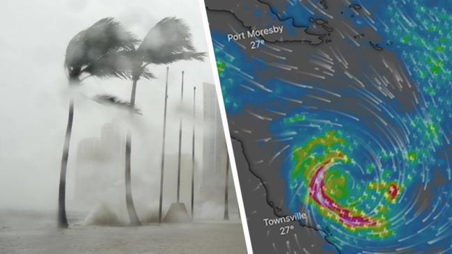
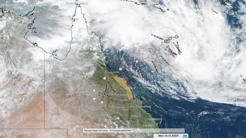
The Bureau of Meteorology, in an update just before 11am AEST today, warned the system was developing slowly in the central Coral Sea and likely to form into Cyclone Kirrily tonight.
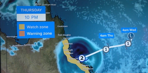
It is expected to make landfall between Cardwell and Airlie Beach as a category 2 storm late tomorrow.
Premier Steven Miles said the region was well-accustomed to cyclones of this nature, and local mayors had confirmed they were ready and well-prepared.
The warning zone stretches from Ayr to Sarina, including Mackay, Bowen and the Whitsunday Islands.
A watch zone is in place from Innisfail to Ayr, including Townsville, and heading inland to Charters Towers.
Residents can expect the wind and rain to intensify as early as this afternoon.
Bureau of Meteorology senior meteorologist Laura Boekel warned a category 2 storm could cause minor damage to homes, significant damage to signs, fell large trees and cause power outages and the system would remain a threat after it crossed the coast.
Damaging wind gusts up to 120km/h are expected on the Whitsundays from this afternoon with destructive 155km/h gusts on the mainland from tomorrow.
Emergency services have engaged residents in communities most likely to be worst affected but are warning people across the entire state to keep informed throughout the long weekend.
Weakened system could dump heavy rain
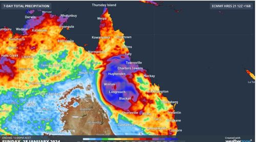
The bureau is anticipating the cyclone to downgrade into a tropical low, dumping intense rainfall as it travels inland throughout Friday and into the weekend.
“It’s important to note that it’s not just about the crossing but what the system will do once it has crossed the coast,” Boekel said.
“So heavy rainfall, riverine flooding and flash flooding will all remain a risk as the system moves inland after crossing.
“It has a really large amount of water associated with that which can produce very heavy rainfall, long after it becomes a tropical low and decreases from the Tropical Cyclone rank.”
Although the cyclone is no longer expected to track towards the state’s south-east, the region is still likely to experience storms with heavy rainfall.
“There are still areas of southern and south-east Queensland that could see quite heavy rainfall over the weekend,” Boekel said.
“So while it would not be a direct impact from the low, it would be an indirect impact, so there is still a lot of moisture in the atmosphere and any shower, storm activity that we see in the south-east or central parts of Queensland over the long weekend could still produce heavy rain that leads to flash flooding as a result of this tropical low.”
Final day to prepare
Townsville locals today sweltered through heatwave conditions to prepare their homes, which are in the firing line of the cyclone.
“This is the third (carload of sandbags). That will hopefully be our final – it’s 10 kilograms per bag, it gets pretty heavy in there,” Lewis, a resident, said.
“I hope (the cyclone is) a fizzer, there’s always hope, but you’ve got to prep for the worst.”
The slow movement of the system was giving communities time to prepare, Deputy Police Commissioner Shane Chelepy said this afternoon.
“As I’ve said before, we are preparing for both cyclone and the flooding that follows it,” he said.
“Our catchments are very wet and they will respond quickly to rain that comes through.
“The swift water rescue crews from (Queensland) Fire and Emergency Services, Energy Queensland, police and other emergency services have now been deployed right across the state to manage both the cyclone crossing and potential flooding event thereafter.”
A further 46 personnel from NSW and eight from Victoria had also been deployed.
Local disaster management websites would have the most up-to-date information for affected communities, Chelepy said.
“Now is the time to start having the conversation with your family, the ‘what if’ conversations,” he said.
“What if my house gets damaged, what if I get flooded, where do I go and how do I get there?”
Residents within the watch zone are urged to prepare long-life food and water supplies, fill up their vehicles with petrol and have a power pack at home as it could take emergency services up to 72 hours to reach devastated towns.
They are also advised to lock away loose outdoor items around their properties.
Townsville Airport will be closed from midday tomorrow and Queenslanders are advised to reconsider travel in regions likely to be affected.